
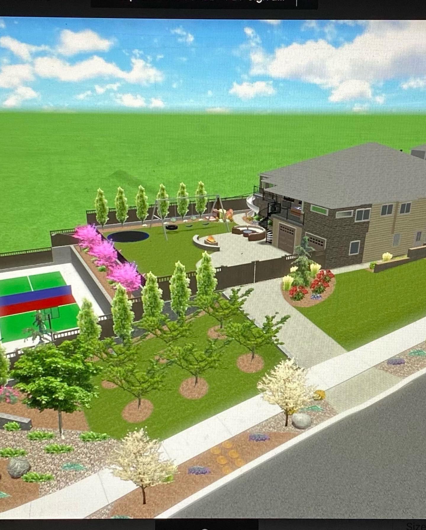
When a homeowner sits down with a landscape contractor and hears the words "design plan," they might picture anything from a hand-drawn sketch to a photorealistic rendering of their finished backyard. The gap between those two things is significant — and understanding it before you sign a contract can save you from expensive surprises during construction.
This article explains what a 2D landscape plan actually contains, what a 3D rendering adds, when each is appropriate, and — critically — what neither one replaces. We will use a real South Jordan project to illustrate the difference, because the contrast between a dimensioned layout plan and a Belgard Design Studio rendering of the same property makes the distinction concrete.
Start With a Design Consultation
Tell us about your property, your goals, and your timeline. We will walk you through whether a 2D plan, a 3D rendering, or both makes sense for your project.
What Is a 2D Landscape Plan?
A 2D landscape plan is a scaled, dimensioned drawing viewed from directly overhead — a bird's-eye layout of your property. It shows property boundaries, the house footprint, existing structures, and the proposed placement of every new element: patio areas, walkways, retaining walls, planting beds, lawn zones, drainage swales, irrigation zones, and utility locations.
The defining characteristic of a 2D plan is that it is drawn to scale. A dimension on the plan corresponds to a real measurement on the ground. A crew can pull measurements directly from the plan to set forms, establish grades, and confirm material quantities. That is what makes it a construction document rather than a visualization.
Think of it as the difference between a blueprint and a photograph of a finished building. The photograph shows you what the building looks like. The blueprint tells the crew how to build it. A 2D landscape plan is the blueprint. A 3D rendering is closer to the photograph — useful for approval, not sufficient for construction.
What a 2D plan typically includes
- Property boundary and setback lines
- House footprint and existing hardscape
- Proposed patio, walkway, and driveway outlines with dimensions
- Retaining wall locations and approximate top-of-wall elevations
- Planting bed outlines and lawn areas
- Drainage flow arrows and approximate grades
- Irrigation zone boundaries
- Utility and easement callouts
- Material callouts (paver type, wall system, edging)
- North arrow and scale bar
A well-executed 2D plan is the foundation of every professional landscape project. Without it, a contractor is estimating material quantities from memory and setting layout by eye. That is how projects end up with patios two feet narrower than the homeowner expected, or retaining walls that conflict with a utility easement discovered mid-excavation.
The 2D plan is also the document that travels to the permit office, the engineer, and the irrigation designer. It is the shared reference that keeps every party working from the same set of facts. A rendering cannot serve that function — it has no dimensions, no grade callouts, and no utility notation.
Key point
A 2D plan is a communication and construction document. Its primary audience is the crew building the project, not the homeowner visualizing the finished result. That distinction matters when you are deciding what level of design investment is appropriate for your project.
What Is a 3D Landscape Rendering?
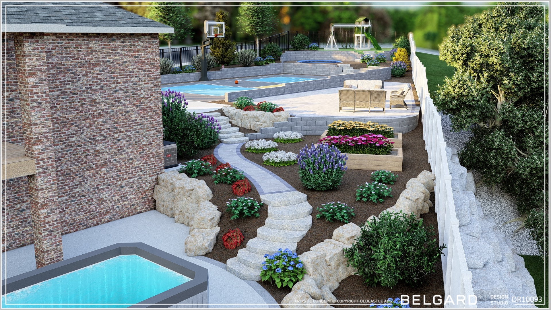
A 3D landscape rendering is a photorealistic or near-photorealistic visualization of the finished project, viewed from a chosen camera angle. Modern landscape design software — including Belgard Design Studio, which Black Diamond uses — can generate multiple views of the same design: overhead, eye-level, corner angles, and even walkthrough sequences.
The rendering is built on top of the same spatial data as the 2D plan. The software places 3D models of the selected paver patterns, wall systems, plant species, lighting fixtures, pergola structures, and water features into a model of the property. The result is an image that shows the homeowner what the finished space will look, feel, and flow like — before a single shovel enters the ground.
What a 3D rendering adds
- Photorealistic material appearance (paver color, texture, pattern scale)
- Spatial relationships between zones — how the patio connects to the lawn, the wall to the pool deck
- Plant massing and mature-size approximations
- Lighting effects at dusk or night
- Grade changes visualized as actual slopes, not just elevation callouts
- Pergola, shade structure, and vertical element proportions
- Water feature scale and placement relative to seating areas
- Multiple camera angles to evaluate the design from different vantage points
The rendering is primarily a homeowner communication tool. It answers the question a 2D plan cannot: "What will this actually look like when it is done?" For projects with significant investment, complex grade changes, or multiple interconnected outdoor zones, that question is worth answering before construction begins.
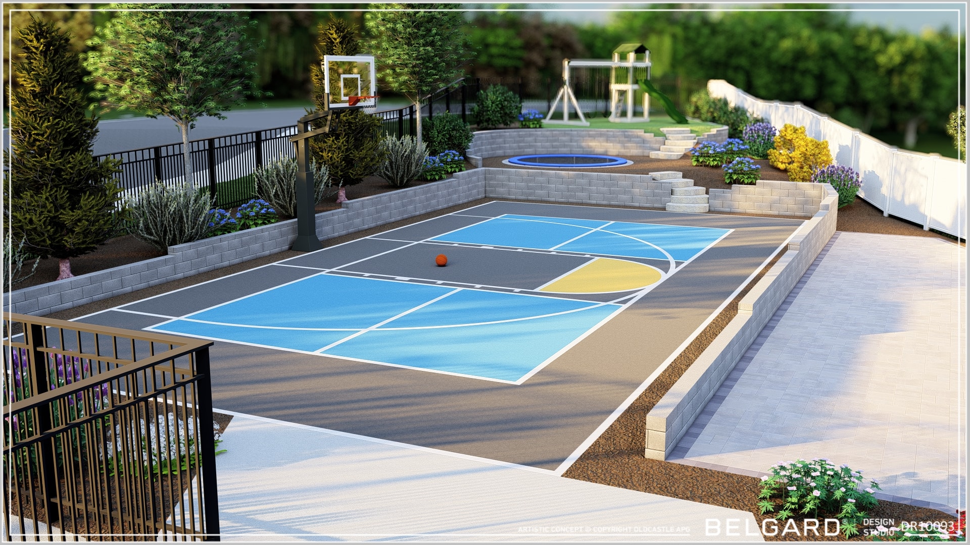
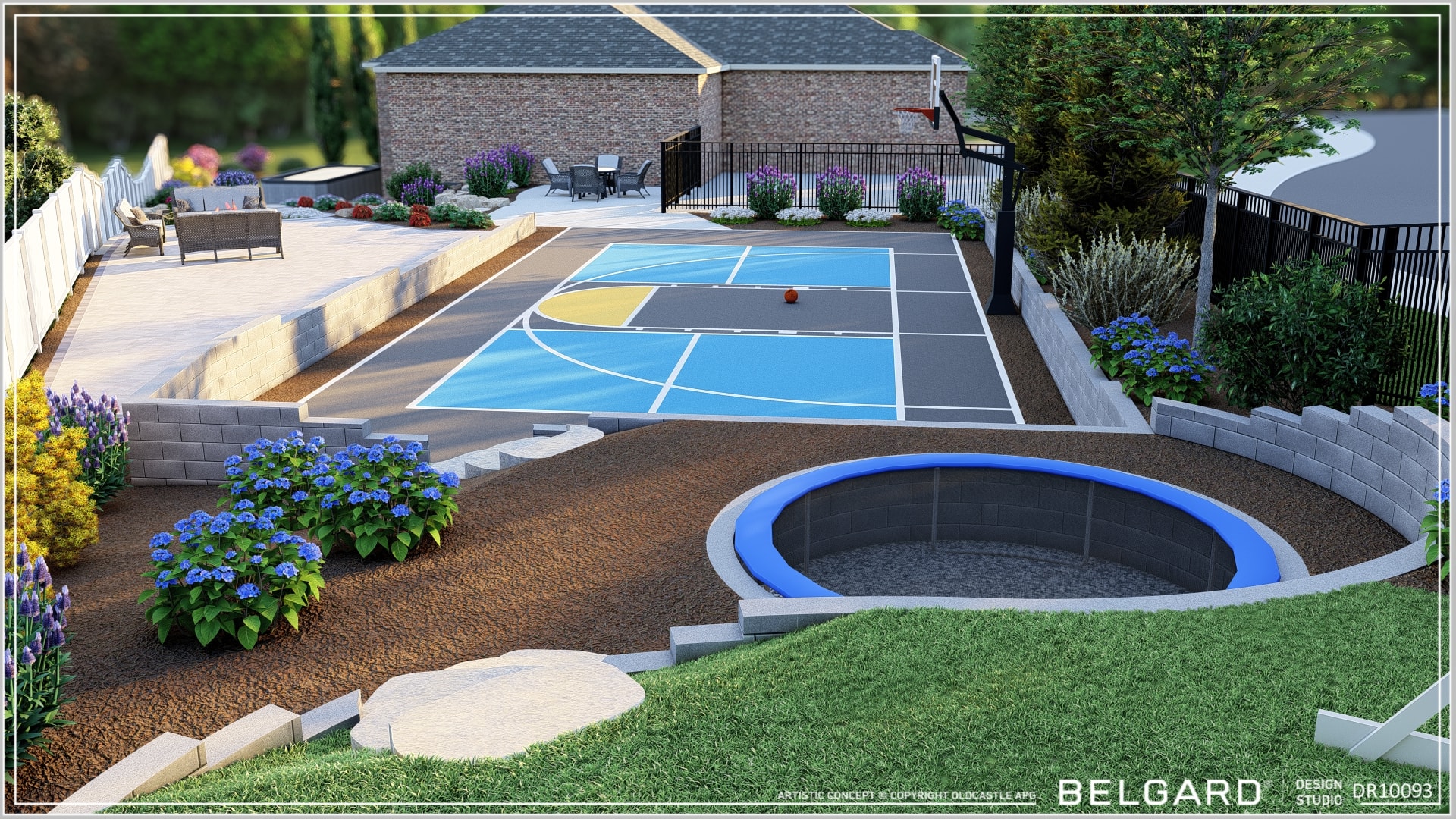
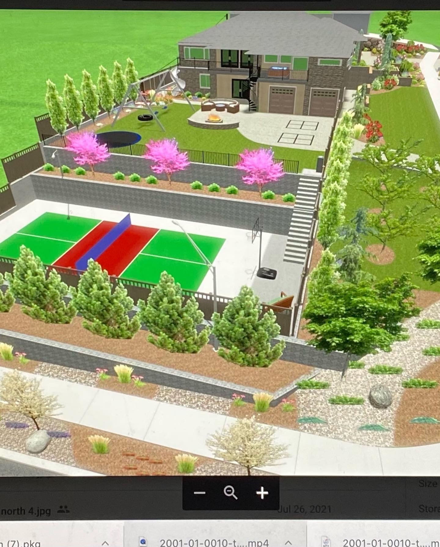
About the project shown: The renderings throughout this article are from a South Jordan design-build project completed by Black Diamond. The 3D models were produced in Belgard Design Studio using the confirmed paver and wall system selections, site measurements, and the approved 2D layout plan. The finished project matched the renderings closely — which is the point.
2D vs 3D: Side-by-Side
The table below summarizes the practical differences. Neither format is universally superior — they serve different purposes and different audiences.
| Attribute | 2D Layout Plan | 3D Rendering |
|---|---|---|
| Primary audience | Construction crew | Homeowner |
| View angle | Overhead (plan view) | Any angle — eye-level, aerial, corner |
| Scale accuracy | Dimensioned and to scale | Proportional; not a dimensioned document |
| Material appearance | Callout labels only | Photorealistic color, texture, pattern |
| Grade changes | Elevation callouts and contours | Visualized as actual slopes and steps |
| Plant representation | Circles with species labels | Approximate mature-size 3D models |
| Lighting | Fixture locations marked | Dusk/night rendering available |
| Used for permitting | Yes (with engineering additions) | No |
| Used for material quantities | Yes | No |
| Answers "what will it look like?" | Partially | Yes |
| Answers "where does everything go?" | Yes | Partially |
| Replaces construction documents | Partially (with additions) | No |
The most important row in that table is the last one. A 3D rendering is not a construction document. We will return to that point in detail — it is the most consequential misunderstanding in landscape design.
When a 2D Plan May Be Enough
Not every project requires a 3D rendering. For straightforward scopes, a well-executed 2D plan combined with physical material samples — paver chips, wall block samples, plant photos — gives a homeowner enough information to make confident decisions.
Projects where 2D is typically sufficient
For these project types, the homeowner's primary questions are: Where does it go? How big is it? What material? A 2D plan with dimensions and material callouts answers all three. Adding a 3D rendering would increase design cost without meaningfully reducing construction risk or homeowner uncertainty.
The practical test: if you can hold a material sample next to the plan and picture the finished result with reasonable confidence, a 2D plan is sufficient. If you find yourself saying "I can't really tell how this is going to feel" — that is the signal that a rendering would be worth the investment.
Contractor note
At Black Diamond, every project begins with a 2D layout plan regardless of scope. The 2D plan is the construction document. The question is whether we also produce a 3D rendering to help the homeowner approve the design before we build it. For smaller, simpler scopes, the plan plus a site walk is usually enough. For complex projects, the rendering pays for itself in avoided change orders.
When 3D Becomes Especially Valuable
Three conditions make a 3D rendering worth the additional design investment: significant grade change, multiple interconnected outdoor zones, and high material investment where a mid-build change of mind would be costly.
Significant grade change
Utah's Wasatch Front is not flat. Many properties in South Jordan, Draper, Sandy, and Cottonwood Heights involve slopes of 10 to 30 percent or more. A 2D plan shows grade changes as contour lines and elevation callouts — useful for the engineer and the crew, but abstract for most homeowners. A 3D rendering shows the grade change as the homeowner will actually experience it: a series of terraced retaining walls stepping down to a lower patio, a staircase connecting zones, a hillside planting bed visible from the kitchen window.
When a homeowner can see the grade change rendered at eye level, they can evaluate whether the wall heights feel right, whether the stair count is comfortable, and whether the lower zone feels connected to the upper zone or isolated from it. Those are design decisions that are very difficult to reverse after the walls are built.
Multiple interconnected outdoor zones
A project that includes a patio, a sport court, a pool deck, a fire feature, a pergola, and a planting area involves spatial relationships that are genuinely hard to evaluate from a 2D plan alone. How does the sport court relate to the pool? Does the fire feature feel too close to the pergola? Is the transition from the patio to the lawn zone natural or awkward?
The South Jordan project shown in this article is a good example. The 2D plan established the dimensions and placement of every element. The 3D rendering answered the spatial relationship questions — and led to a minor adjustment in the sport court orientation before excavation began. That adjustment would have cost significantly more to make after the retaining walls were poured.
High material investment
Belgard paver systems, natural stone caps, custom wall block, and premium lighting fixtures represent a meaningful investment. A homeowner who is committing to a specific paver color and pattern across 2,000 square feet of patio and walkway deserves to see what that material will actually look like in context — not just on a sample chip — before the order is placed. A 3D rendering produced with the confirmed material selections gives them that confidence.
The cost of a mid-build change: Changing a paver selection after the base is compacted and the first course is laid means pulling up installed material, returning or restocking product, reordering, and waiting for delivery. On a large project that can mean a week of delay and several thousand dollars in labor and restocking costs. A rendering that surfaces the preference change before installation begins costs a fraction of that.
A 3D Rendering Is Not Automatically a Construction Plan
This is the most important distinction in this article, and the one most frequently misunderstood by homeowners — and occasionally by contractors.
A 3D rendering is a visualization. It shows what the finished project could look like. It does not, by itself, tell a crew where to set forms, what grade to establish, how deep to excavate, what base depth to use, or how to handle drainage. A rendering produced without a corresponding dimensioned 2D plan is a picture without instructions.
What a construction document must include that a rendering does not
- Dimensioned layout with measurements to property lines and structures
- Finished grade elevations at key points
- Base depth specifications for each paved surface
- Retaining wall embedment and batter specifications
- Drainage plan with flow directions and outlet locations
- Utility locations and required clearances
- Material specifications with product codes, not just visual descriptions
- Irrigation zone map with head types and spacing
- Lighting circuit layout and fixture specifications
- Engineering stamp where required by local jurisdiction
A contractor who builds from a rendering alone — without a dimensioned plan — is making assumptions about every one of those items. Some assumptions will be fine. Others will produce a patio that drains toward the house, a retaining wall that fails in the first wet spring, or a layout that conflicts with a utility easement.
What to ask your contractor
Before signing a design-build contract, ask: "What documents will the crew use to build from?" The answer should include a dimensioned 2D plan with grade callouts, a material specification sheet, and a drainage plan. A rendering alone is not a sufficient answer. If the contractor cannot produce those documents, that is a meaningful risk signal.
At Black Diamond, the 3D rendering and the 2D construction plan are produced together from the same site data. The rendering helps the homeowner approve the design. The 2D plan and specification documents guide the build. They are complementary tools, not substitutes for each other.
Why Design Can Reduce Rework
The business case for investing in design — whether 2D, 3D, or both — is straightforward: decisions made on paper are cheap. Decisions reversed after construction has begun are expensive.
The most common sources of mid-build rework in landscape construction are not technical failures. They are preference changes that the homeowner could not anticipate from a verbal description or a rough sketch. "I didn't realize the patio would feel that small." "The wall is higher than I expected." "I thought the sport court would be further from the house." These are not unreasonable reactions — they are the natural result of trying to evaluate a three-dimensional space from a two-dimensional description.
Where rework costs accumulate
- Patio size changes after base compaction — requires re-excavation and additional base material
- Retaining wall height changes after footings are poured — may require engineering revision
- Paver pattern or color changes after material is delivered — restocking fees, reorder lead time
- Zone layout changes after irrigation is roughed in — additional trenching and pipe
- Lighting circuit changes after conduit is buried — additional trenching
- Pergola location changes after post footings are poured — new footings required
A 3D rendering surfaces most of these preference questions before construction begins. A homeowner who has approved a rendering showing the patio at a specific size, the wall at a specific height, and the paver in a specific color has made those decisions deliberately — not by default. The probability of a mid-build reversal drops significantly.
The design fee for a project that includes both a 2D plan and a 3D rendering is typically a small fraction of the total project cost. On a complete multi-zone landscape project of the type shown in this article, a single avoided change order often covers the entire design investment.
Designing for Utah Conditions
Utah's climate and terrain introduce design considerations that are not present in most national landscape design guides. A design process that does not account for them produces plans that look good on screen and fail in the field.
Freeze-thaw cycles and base depth
The Wasatch Front experiences significant freeze-thaw cycling from November through March. Paved surfaces — patios, walkways, driveways — require adequate base depth and compaction to prevent heaving. The standard residential paver base in Utah is typically 6 to 8 inches of compacted Class II road base, with additional depth on slopes or in areas with poor native soil drainage. A design that specifies base depth based on a national standard rather than local soil and climate conditions will produce a patio that heaves within three to five years.
Slope and drainage
Many Wasatch Front properties sit on slopes that concentrate runoff during spring snowmelt and summer monsoon events. A landscape design that does not include a drainage plan — not just drainage arrows on a 2D plan, but a specified outlet, pipe sizing, and connection to an appropriate discharge point — is incomplete. Retaining walls on sloped sites require drainage aggregate and perforated pipe behind the wall face; without them, hydrostatic pressure will eventually cause wall failure regardless of the wall system quality.
Water-wise design requirements
Several Utah municipalities — including Salt Lake City, Sandy, and South Jordan — have adopted water-wise landscaping requirements for new construction and significant renovation. A design plan should identify turf areas, irrigation zones, and plant selections in a way that supports compliance with local water budgets. The irrigation design and plant selection components of a landscape plan are not optional add-ons in Utah — they are part of responsible design practice.
Material performance in Utah conditions
Not all paver and wall systems perform equally in Utah's climate. Belgard's concrete paver and wall systems are manufactured to ASTM standards that include freeze-thaw durability testing. Natural stone — flagstone, quartzite, travertine — varies significantly in absorption rate and freeze-thaw resistance depending on the specific material and source. A design that specifies materials without considering their performance in Utah's climate is an incomplete design.
This is one reason Black Diamond works primarily with Belgard hardscape systems. The performance specifications are documented, the installation requirements are standardized, and the warranty is backed by a manufacturer with a national service network. When a homeowner is making a significant investment in hardscape, material performance documentation matters.
How Black Diamond Connects Design to Construction
Black Diamond is a design-build firm. We do not hand off a design to a separate contractor — the team that designs the project builds it. That continuity matters for the reasons described above: the design documents are not just a sales tool, they are the instructions the crew works from.
Our design process for qualifying projects
- Site visit and measurements — we measure the property, photograph existing conditions, and note utility locations, drainage patterns, and grade
- Design consultation — we discuss your goals, priorities, budget range, and material preferences
- 2D layout plan — a dimensioned overhead plan showing all proposed elements, grades, and drainage
- 3D rendering — produced in Belgard Design Studio using confirmed material selections and site measurements
- Design review — we walk through the rendering with you, answer questions, and make adjustments before finalizing
- Construction documents — final dimensioned plan, material specification sheet, irrigation design, and lighting layout
- Build — the same team that designed the project executes it
The 3D rendering review step is where most preference decisions get resolved. By the time we move to construction documents, the homeowner has seen the project from multiple angles, confirmed the material selections, and approved the spatial layout. The construction documents translate those approved decisions into buildable instructions.
What we do not do
We do not produce renderings as a sales tool disconnected from construction documents. A rendering that is not backed by a dimensioned plan and material specifications is a promise we cannot reliably keep. Every rendering we produce is built from the same site data and material selections that will be used to build the project.
We also do not use renderings to obscure scope. If a project element shown in a rendering is not included in the contract scope — a pool, for example, shown for context but not in the build scope — that is clearly noted in the design review and the contract.
The Goal Is Not Just a Better Rendering
It would be easy to read this article and conclude that the goal of the design process is to produce the most impressive-looking rendering. That is not the goal.
The goal is a finished project that matches what the homeowner approved, performs correctly in Utah's climate, and holds up over time. The rendering is a tool in service of that goal — it helps the homeowner make confident decisions before construction begins, which reduces the probability of costly mid-build changes and post-build disappointment.
A rendering that looks beautiful but is not backed by accurate site data, confirmed material selections, and a dimensioned construction plan is a liability, not an asset. It creates expectations the build cannot meet.
The South Jordan project shown in this article is a useful benchmark. The renderings were produced from measured site data and confirmed Belgard material selections. The finished project matched the renderings closely — not because the software is magic, but because the data behind the rendering was accurate. That accuracy is the product of the design process, not the rendering software.
The bottom line
Invest in design proportional to the complexity and cost of your project. For simple scopes, a 2D plan with material samples is sufficient. For complex multi-zone projects with significant grade change and material investment, a 3D rendering pays for itself in avoided rework and homeowner confidence. In either case, make sure the design documents are complete enough to build from — not just beautiful enough to approve.
Start With a Design Consultation
Tell us about your property, your goals, and your timeline. We will walk you through whether a 2D plan, a 3D rendering, or both makes sense for your project.
Common Questions
Does a 3D rendering replace a construction plan?
No. A 3D rendering is a visualization tool. Construction requires dimensioned drawings, material specifications, grading plans, and in some cases engineering stamps. The rendering helps you approve the design; the construction documents guide the build. At Black Diamond, both are produced from the same site data.
How accurate are 3D landscape renderings?
Accuracy depends on the data behind the model. Renderings built from a measured site survey and confirmed material selections are highly representative of the finished project. We base our renderings on site measurements and confirmed Belgard material selections, which is why our finished projects match the renderings closely.
Is 3D design worth the cost for a smaller project?
For straightforward projects — a single patio, a simple planting bed, a walkway — a 2D plan with material samples is often sufficient. 3D becomes most valuable when the project involves grade changes, multiple outdoor zones, or significant hardscape investment where a change-of-mind mid-build would be costly. We will tell you honestly which approach makes sense for your scope.
Can I see my actual yard in the rendering?
Yes. Belgard Design Studio can incorporate site photos and measurements to produce a rendering that reflects your actual property boundaries, grade, and existing structures. The result is more representative than a generic template, which is why we invest in accurate site measurement before producing any rendering.
What does Black Diamond include in its design process?
Our process begins with a site visit and measurements, followed by a design consultation. For qualifying projects we produce both a 2D layout plan and a 3D rendering using Belgard Design Studio. The design is refined with you during a review session before construction documents are finalized. The same team that designs the project builds it.
Can landscape design help with a Utah Water Savers rebate?
Yes, depending on the program. Certain Utah Water Savers programs may require a property-specific 2D landscape design as part of the application. Eligibility and incentive amounts depend on location, participating water provider, and current program requirements. See our guide to Utah landscape water rebate programs for a full breakdown of available programs and how Black Diamond coordinates the application process.
Can a landscape plan include irrigation and drainage?
Yes, depending on the scope. Irrigation layouts, drainage concepts, and grading relationships can be coordinated during landscape planning, although more complex conditions may require specialized design or engineering.
Do you work in my area?
Black Diamond serves the Wasatch Front including Salt Lake City, South Jordan, Sandy, Draper, Cottonwood Heights, Murray, Riverton, Herriman, West Jordan, Millcreek, Holladay, and surrounding communities. Contact us to confirm service availability for your specific location.
Start With a Design Consultation
Tell us about your property, your goals, and your timeline. We will walk you through whether a 2D plan, a 3D rendering, or both makes sense for your project.